
Slea Head is the most westerly point on mainland Ireland. It lies on the tip of the beautiful Dingle Peninsula in County Kerry and one of the best ways to get around and explore the area is by bicycle!

english/german
Slea Head ist der westlichste Punkt auf dem irischen Festland. Es liegt an der Spitze der Dingel Halbinsel in der Grafschaft Kerry und eine der schönsten Arten die Gegend zu erforschen ist mit dem Fahrrad!
Der Slea Head Drive führt immer die Küste entlang rund um die Landzunge, mit Dingle Town als Ausgangs- und Endpunkt. Die Umrundung schafft man in ca. drei Stunden, allerdings gibt es unterwegs soviel zu sehen, daß es leicht länger dauern kann. Der Ausblick über die Blasket Inseln und die Klippen entlang der Küste ist spektakulär, unterwegs gibt es einige historische Stätten, die man besichtigen kann und ein paar schöne Strände, die sich für eine kleine Rast eignen.
It takes about three hours, but there´s so much to see, it might easily take you longer than that. The views out over the Blaskets Islands and the cliffs along the coast are spectacular, there´s some very nice beaches for a break and some historical sites to explore along the way.
There´s a number of places that rent bikes in Dingle Town, for example at:
In Dingle kann man Räder ausborgen, zum Beispiel hier:
http://www.lanterntownhouse.com/bedrooms.asp?p=rent-a-bike-at-lantern-townhouse
or at:
Fios Feasa Rent a Bike (Holy Ground, Dingle, Co. Kerry, 066/915-1606)
Paddy's Bicycle Hire (Dykegate Lane, Dingle, Co. Kerry, 066/915-2311)
Foxy John Moriarty (Main Street, Dingle, Co. Kerry, 066/915-1316)
.JPG) |
| Colourful Dingle town |
The route starts in Dingle town, leaving the town going west on the R559, the Slea Head Drive is well sign posted. As soon as we leave Dingle town behind, the rural countryside takes over. The narrow road is lined with wild blackberry shrubs.
Die Route startet in Dingle, wir verlassen die Stadt in westlicher Richtung auf der R559. Der Slea Head Drive ist gut ausgeschildert. Sobald wir Dingle Town hinter uns lassen, sind wir mittendrin in der Natur. Wilde Brombeersträucher säumen die schmale Landstrasse.
 |
| Dingle Peninsula with Mount Brandon in the distance |
After six kilometres the road leads down to Ventry Bay with its beautiful beach. Ventry Strand is a Blue Flag Beach, meaning it has best water quality and is safe for swimming.
Nach sechs Kilometer führt die Strasse zum Ventry Bay mit ihrem wunderschönen Strand. Der Strand ist mit dem Blaue Flagge Gütesiegel ausgezeichnet, hat also beste Wasserqualität und ist ein sicherer Badestrand.
.JPG) |
| Ventry beach |
.JPG) |
| Looking out to the sea |
.JPG) |
| View over Ventry Bay |
Hinter Ventry Bay wirkt die Gegend immer einsamer, wir sind jetzt tief in der Gaeltacht, der irisch sprechenden Gemeinde, mit allen Ortsschildern und Verkehrszeichen in irischer Sprache.
Unterwegs lässt es sich kaum vermeiden, daß man auch einigen Einheimischen begegnet...!
 |
| Some of the Dingle peninsula locals |
 |
| more locals |
Die Route führt immer die Steilküste entlang, das Rauschen der Wellen und Blöken der Schafe ist so ziemlich die einzige Geräuschkulisse unterwegs. Hier fällt die Küste so steil ins Meer hinab, daß die Schafe, die hier grasen besonders standfest und schwindelfrei sein müssen.
 |
| vertigo free sheep |
Find out more about the fort here:
http://www.dunbegfort.com/
Auf halber Strecke zwischen Ventry und Slea Head, in dem kleinen Dorf Fahan, steht "Dun Beg" - ein Stein Fort aus dem Eisenzeitalter. Dun beag ist irisch und heißt "kleines Fort". Das Fort steht direkt an der Steilklippe, für ein kleines Eintrittsgeld kann man hinunter gehen und durch die schmale Eingangspassage ins Innere des Forts klettern.
Hier kann man mehr über Dun Beg Fort lesen:
http://www.dunbegfort.com/
 |
| Don´t miss Dunbeg Fort! |


Perched up on the hillside on the other side of the road you can also visit three of the beehive huts typically found in the West of Ireland. They were built during the Iron Age, some were used as storage barns or stables well into the twentieth century.
Also in Fahan you can find the Famine Cottage Museum, an old 19th century cottage restored to give an impression of what life was like during the famine years and beyond.
Read more about the Famine Cottage here:
http://www.famine-cottage.com/
Auf der anderen Strassenseite, ein Stück den Hügel bergauf, kann man drei der für den Westen Irlands typischen Bienenkorbhütten (Kraggewölbebauten aus Trockenmauerwerk) besichtigen. Sie wurden während der Eisenzeit erbaut, mache wurden noch bis ins 20. Jahrhundert als Lagerräume oder Ställe benutzt.
In Fahan befindet sich auch das Famine Cottage Museum, ein restauriertes Bauernhaus aus dem 19. Jahrhundert, das einen guten Eindruck vom harten Leben während der Jahre der Hungersnot gibt.
Mehr übers Famine Cottage Museum:
http://www.famine-cottage.com/
.JPG) |
| Famine Cottage in Fahan |
 |
| Inside the Famine Cottage you get a good idea of how people lived back then |
 |
| The Museum also keeps a few animals on the premises. |
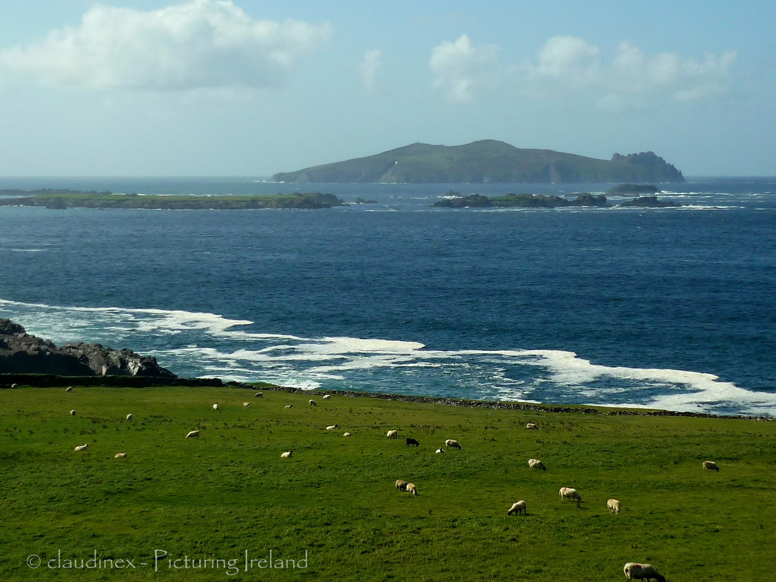
A few kilometres down the road we reach Slea Head itself, marked by a stone crucifixion scene, with stunning views of the Blasket Islands. The Blaskets are the westernmost point of Ireland, and were inhabited until 1953 when the last of the irish speaking islanders moved across the bay to the mainland.
Ein paar Kilometer weiter erreichen wir den berühmten Slea Head, gekennzeichnet durch ein weißes Kreuzigungs-Denkmal, mit atemberaubenden Ausblick über die vorgelagerten Blasket Inseln. Diese Inseln sind der westlichste Punkt Irlands, sie waren bis 1953 noch bewohnt, dann zogen die letzten irisch sprechenden Bewohner hinüber aufs Festland.
 |
| Dramatic views over the Blasket Islands |
 |
| Inishtooskert, the northernmost of the Blaskets is also called "The Sleeping Giant" |
Scenes for the David Lean movie "Ryan´s Daughter" with Sarah Miles and Robert Mitchum were filmed here in 1970. This beach is also popular with surfers.
Ums Eck liegt einer der spektakulärsten Strände Irlands - Coumeenoole Strand.
Szenen für den David Lean Film "Ryan´s Daughter" mit Sarah Miles und Robert Mitchum sind hier 1970 gedreht worden. Der Strand ist auch unter Surfern sehr beliebt.
.JPG) |
| Coumeenoole Strand and Dunmore Head |
.JPG)

 |
| Craggy rock formation on Dunmore Head |
The road goes on to the Gaeltacht village Dunquin (Dún Chaoin meaning "Caon's stronghold").
From there you can catch the ferry to the Blasket Islands and explore unspoiled nature, beautiful beaches and the abandoned villages.
Or you can visit the Blasket Visitors Centre located in the village. The exhibit will take you back in time and gives a unique insight into the extraordinary lives of the Blasket Islanders. Many of the Islanders had the gift of story telling and their stories and biographies have been written down and published.
Die Strasse führt weiter ins Gaeltacht Dorf Dunquin (Dún Chaoin bedeutet "Caon´s Festung").
Von hier kann man die Fähre auf die Blasket Inseln nehmen und unberührte Natur, schöne Strände und die verlassenen Dörfer erforschen.
Oder man kann das Blasket Besucherzentrum im Dorf besuchen. In der Ausstellung wird man in die Vergangenheit zurück versetzt und gewinnt einen Einblick in die außergewöhnlichen Lebensgeschichten der Inselbewohner. Viele der Inselbewohner hatten die Gabe des Geschichten erzählens, ihre Erzählungen und Biographien wurden aufgeschrieben und veröffentlicht.
 |
| Dunquin |
Von Dunquin führt die Strecke um die Spitze der Dingle Halbinsel herum zum Clogher Head.
.JPG) |
| Onwards and upwards! |
Der Ausblick vom Clogher Head ist großartig, Clogher Strand und die Hügelkette am Horizont, bekannt als die "drei Schwestern".
 |
| Clogher Head |
From Clogher Head the road turns inland and runs into the village of Ballyferriter.
Gallarus Oratory, an early christian church built by monks completely out of stones, is a few kilometres down the road.
From there you can go on to Ballydavid and then back to Dingle town around the base of Mount Brandon.
Von Clogher Head führt die Strasse nun landeinwärts bis nach Ballyferriter.
Die frühchristliche Steinkirche Gallus Oratory liegt ein paar Kilometer weiter.
Von hier führt die Strecke weiter nach Ballydavid und dann entlang des Fußes von Mount Brandon bis zurück nach Dingle town.
 |
| Mount Brandon in the distance |
 |
| It´s hard to get lost on the Dingle Peninsula |
We however, took a shortcut and turned right outside of Ballyferriter, and rode our bikes all the way downhill to Ventry and then back to Dingle.
Wir haben allerdings die Abkürzung genommen und sind außerhalb von Ballyferriter rechts abgebogen, von da gings mit den Rädern fast nur mehr bergab, bis nach Ventry und dann zurück nach Dingle.
 |
| Dingle Harbour |
My sisters, niece & I were in Dingle about 7 years ago and I can't wait to go back! Your pictures are beautiful...and you describe it all so well!! I look forward to checking out more of your blog and your Facebook page!
ReplyDeleteThanks a lot, Marilyn, much appreciated! Dingle is such an incredibly beautiful place, and there´s just so much to do & see! Must go back soon..!
ReplyDeleteBeautiful, Beautiful, Beautiful. I haven't been since 1980. But am planning on returning this summer. And I wouldn't do the trip without a bike ride to Slea Head and Dunquin for sure. Thank you for sharing these.
ReplyDeleteYou're very welcome, Kathleen. Cycling is the best way to see the Dingle peninsula - wishing you lots of fun this summer!
ReplyDelete