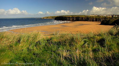
The scenic walk along the Ballybunion Cliffs in North County Kerry offers views of spectacular seascapes and hidden beaches, as well as a bit of local folklore and history.
(scroll down for german version)
Ballybunion is a typical seaside resort with sandy beaches, dunes, two golf courses, arcades and seaweed baths. But there's also the ruin of a medieval Geraldine castle, prominently built on the rocky headland overlooking the coast and the wide Shannon Estuary.
Join me on the walk along the Ballybunion Cliffs with its spectacular seascapes, rock formations, blow holes, secluded
beaches and panoramic views over the North Kerry coast.
The walk starts near the seaweed baths, a signpost points you towards the stairs leading up to the top of the cliff. On top, the path follows the coastline along the wide sandy beach. The remains of the 14th century Ballybunion Castle overlooks the village and divides the sandy beach into two parts. Back in the days men and women had to bathe separately, the beaches are still called 'Ladies beach' and 'Men's beach'. The story goes that a priest watched from the castle ruins, making sure they didn't mingle.
At the western end of the cliffs, before turning right you can see as far as
Kerry Head in the south and Loop Head across the estuary in County Clare.
 |
| The remains of the clifftop castle |
A little further ahead there's a blowhole - known as the 'Nine Daughters Hole'. Local lore tells the gruesome story of the O'Connor chieftain who had his nine (!) daughters thrown down the chasm into the raging sea below after finding out they had fallen in love with foreign Viking warriors. (Today, the blowhole is fenced off for safety reasons!)
 |
| The blowhole |
Further along the cliff path there's a small bay with a beautiful secluded sandy beach. The 'Nun's Beach' is named after an old convent which once
stood on top of the cliffs. The prominent sea arch overlooking the small
bay is aptly named 'Virgin's Rock'. The beach is practically inaccessible, surrounded by steep
cliffs on all sides. (It is not known whether the nuns ever tried to scramble down...)
The remains of a small house stand in the middle of the headland. It is
believed that an old promontory fort once stood here, overlooking the
strategically important mouth of the Shannon River. In fact, remains of
promontory forts can be found along the entire North Kerry coast.
From here you can either walk straight which will lead you to the main road or you could just re-trace your steps along the cliff path to get back to the village.
german version:
Der malerische Spaziergang entlang der Ballybunion Klippen im Norden der Grafschaft Kerry bietet Ausblicke über die spektakuläre Meereslandschaft und versteckte Strände, aber auch ein paar regionale Sagen und Geschichte.
Ballybunion ist ein typisches
Seebad mit Sandstränden, Dünen, zwei Golfplätzen, Spielhallen und
Meeresalgen-Bäder. Aber es gibt auch die Ruine einer mittelalterlichen
Burg der Geraldiner, die auf einer Felsklippe über die Küste und die
weitläufige Shannon Mündung wacht.
Komm mit auf einen Spaziergang entlang der Ballybunion Klippen mit ihren
spektakulären Seelandschaften, Felsformationen, einsamen Stränden und
dem Panorama Ausblick über die Küste Nord Kerrys.
Der Pfad beginnt nahe des Meeresalgen Seebades, ein Wegweiser zeigt
den Weg zu den Treppen, die auf die Klippe führen. Oben folgt der Weg
den Klippen entlang des weiten Sandstrandes.
Die Ruine der Ballybunion Burg aus dem 14. Jhdt. thront über dem Dorf und teilt den Sandstrand in zwei Hälften. Früher mußten Männer und Frauen getrennt schwimmen gehen - die Strände heißen heute noch 'Ladies Beach' und 'Men's Beach'. Es wird erzählt ein strenger Pfarrer beobachtete die Badegäste von der Burg aus und wachte darüber, daß sich die Geschlechter nicht vermischten.
Am westlichen Ende der
Felswand, bevor der Weg rechts abbiegt, kann man bis zum Kerry Head im
Süden und Loop Head an der anderen Seite der Mündung in der Grafschaft
Clare sehen.
Ein Stück weiter gibt es ein Blasloch (eine
vertikale Aushöhlung des Felsgesteins bis hinab zum offenen Meer) - bekannt als das
'Neun Töchter Loch'. Einer lokalen, grausamen Sage nach soll der
Stammesfürst des O'Connor Clans seine neun (!) Töchter dieses Loch hinab in
die stürmische See geworfen haben, weil sie sich in fremde Wikinger
Krieger verliebt hatten. (Heutzutage ist die Höhle aus Sicherheitsgründen
mit einem Zaun abgesperrt!)
Weiter entlang des Klippenpfads taucht eine kleine Bucht mit einem
wunderschönen einsamen Strand auf. Der 'Nonnenstrand' wurde nach dem
Kloster, das einst auf den Felsklippen stand, benannt. Eine
Felsformation sticht ins Auge - der Felsbogen, der die kleine Bucht
überblickt heißt treffenderweiser 'Jungfrauen Fels'. Der Strand ist
praktisch unzugänglich, er ist von allen Seiten von steilen Klippen
umgeben. (Es ist nicht überlefert, ob die Nonnen je versucht haben
hinunter zu klettern...)
Die Überreste einer kleinen
Behausung stehen in der Mitte der Landzunge. Es wird angenommen, daß
hier einst ein Fels Fort stand, das die strategisch wichtige Shannon
Mündung überwachte. Tatsächlich findet man entlang der gesamten Küste
Nord Kerrys Überreste solcher Klippen Festungen.
Von hier kann man entweder geradeaus bis zur Hauptstraße zurück gehen
oder aber wieder den Klippenpfad zurück bis ins Dorf zurück.


Your blog is very good and very helpful too.I have learned a lot from your blog.Due to your blog, people will be very helpful.I read your blog and it is really good.Thank you for sharing this information with us.
ReplyDeletejournal uni place